Dana Point Geologic
Field Trip
Caroline
Hardeman
Simi
Elementary
AMGEN Earth
Science Institute 2004
Introduction
Students will be visiting Dana Point and the Marine
Institute (www.ocean-institute.org)
as part of our visit to science camp. As
part of our visit to the tide pools at the marine institute, students will
also observe the rocks at the shore and record, in sketches the geology of
the immediate area.
As part of their current science curriculum,
students will be reviewing the basic geological rock types. They will also get a general understanding of
plate tectonics and earthquakes. They
will utilize this understanding in completing their geologic worksheet for the
rock formations at the shore.
Grade 6
Standards
Plate
Tectonics and Earth’s Structure
6.1.a. Students know evidence of plate
tectonics is derived from the fit of the continents; the location of
earthquakes, volcanoes, and midocean ridges; and the distribution of fossils,
rock types, and ancient climatic zones.
6.1.b. Students know Earth is composed of
several layers: a cold, brittle lithosphere; a hot, convecting mantle; and a
dense, metallic core.
6.1.c. Students know lithospheric plates the
size of continents and oceans move at rates of centimeters per year in response
to movements in the mantle.
6.1.e. Students know major geologic events,
such as earthquakes, volcanic eruptions, and mountain building, result from
plate motions.
6.1.f. Students know how to explain major
features of California geology
(including mountains, faults, volcanoes) in terms of plate tectonics.
Investigation
and Experimentation
6.7.b. Students select and use appropriate
tools and technology to perform tests, collect data, and display data.
6.7.e. Students recognize whether evidence is
consistent with a proposed explanation.
6.7.f. Students read a topographic map and a
geologic map for evidence provided on the maps and construct and interpret a
simple scale map.
6.7.g. Students interpret events by sequence
and time from natural phenomena.
6.7.h. Students identify changes in natural
phenomena over time without manipulating the phenomena.
General Lesson
Plan Outline:
Our trip to Dana Point takes place
at the end of the school year. By that
time, students will have covered the following units in their Holt science
texts:
Unit
2 Earth’s Resources
Chapter 3 Minerals of the Earth’s Crust
Chapter 4 Rocks: Mineral Mixtures
Chapter 5 Energy Resources
Chapter 6 The Rock and Fossil Record
Unit 3 The Restless Earth
Chapter 7 Plate Tectonics
Chapter 8 Earthquakes
Chapter 9 Volcanoes
Unit 4
Reshaping the Land
Chapter 10 Weathering and Soil Formation
Chapter 11 The Flow of Fresh Water
Chapter 12 Agents of Erosion and Deposition
Unit 5
Oceanography
Chapter 13 Exploring the Oceans
Chapter 14 The Movement of Ocean Water
The background
knowledge attained during these months of study with the Science teacher, as
well as with extension activities in the general classroom, will prepare
students for our journey down to the ocean.
Students will
practice their knowledge of rocks and the rock cycle on the following sites,
which offer review activities as well.
http://www.fi.edu/fellows/fellow1/oct98/expert/index.html
The Rock
Hounds website is great for review and quick quizzes during student free time:
http://www.geocities.com/RainForest/Canopy/1080/
There is a
word search available at the following site:
http://www.quia.com/ws/86.html
Rock types,
rock cycle
Blank diagrams:
http://www.rocksandminerals.com/rockcycle.htm
www.enchantedlearning.com
Actual lesson (Prior to our
trip)
-
Types
of rocks at Dana Point, especially the San Onofre breccia: We will study the
geologic map of Dana Point, which will be printed out for
students from the following site:
ftp://ftp.consrv.ca.gov/pub/dmg/rgmp/Prelim_geo_pdf/dana_point.pdf
-
Explanation
of the way the shoreline formation was created, and continues to be shaped
today.
Field trip:
-
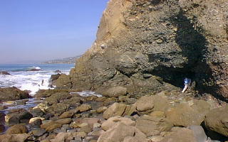
At
the shore, students will need to sketch a section of the cliff
-
We
will also photograph sections of the cliffs behind the tide pools.
-
They
will need to label the rocks within their section based on the images we have
seen in class
After the trip
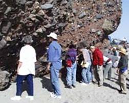
-
Students
will share their sketches and we will compare them to the images we saw prior
to our trip
-
We
will discuss the geologic significance of these cliffs and the marine ecosystem
that exists there.
**Each year,
as another group of 6th grade students visit the shore, we will see
if the sketches have changed from the previous year. We will discuss the changes that have
occurred and the possible causes, such as erosion, weathering and human destruction.